The Miami & Erie Canal was one of the greatest accomplishments of the 1800’s as it linked Lake Erie to the North with the Ohio River to the South. It ferried settlers, livestock and supplies into the new growing state of Ohio. The first canal trip in our area was in December 1828 as a party of Daytonians aboard the packet boat “Alpha” journeyed through Moraine to Holes Creek. Eventually, a 24-hour trip from Dayton to Cincinnati, the boat made a stop at 9am and 2pm to allow passengers to get off, build a fire on the canal bank and cook a meal. The canal meant prosperity for entrepreneurs. You could work on the canal as boatman or toll collector, locate stores or businesses near the canal, or acquire rights to power generated by the canal locks for use in operating gristmills or sawmills.
In the 1880’s, the canal was still a popular recreational destination for a family out for a Sunday excursion where they sat on the top of the canal boat deck and enjoyed the scenery. The development of train transportation and the catastrophic Great Dayton Flood of 1913 put canal boat trafficking and canals out of business.
Captain Billy Combs was a spry 82 year old when he brought the last boat up the canal in 1909 through Moraine. The canal boat was called the “De Camp Statler”. Combs was hauling a big load of gravel from Newport on the last run on record from a payload on the upper canal. Harry Newton, whose father had brought the canal boat over from Wabash was on the last run with Combs. Photo #1 shows Billy pointing to the waterway that he fondly called “his canal”
Is there any visual evidence today remaining of the canal in Moraine? Not much. A canal lock still exists at Carillon Park and the canal winded around Calvary Ridge into Moraine from the North and follows Arbor Blvd. and Dryden Road south. You can see the canal contour of land at Dryden & Krieitzer Road. The old canal toll booth was a log cabin that still exists inside of the business at the corner of Kreitzer Road and Springboro West (Photo #2).
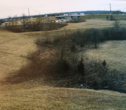
The Moraine Historical Marker at the corner of Dryden Road and East River Road is the spot where Canal Lock #23 was located, lowering the water level going south. Lastly, where Dryden Road dead ends into Central Avenue/Dixie Drive, the canal turned right or southwest and headed into West Carrollton (see Photo#3). Although not much remains today of this major transportation route that brought pioneers to Moraine, its history remains a vital part of how early Moraine was developed.