Expedition Team: Dave Miller, Rosie Miller, Jacque Miller, Holly Miller, Shane Miller
Date: August 2009
One of the most beautiful parks we ever visited. Yosemite NP is located in the Sierra Nevada Mountains known for its sequoia trees, scenic vistas, vast wilderness, waterfalls, hiking and rock climbing. We pulled off and got an excellent photo of Half Dome and El Capitan in the distance (Photo#1). We stayed at a motel just outside the park entrance. We drove into the park and hiked two miles on the Lower and Upper Pine Trails (Photo#3 & #4) and half mile on the Cook’s Meadow Loop Trail which gave us a panorama view of Yosemite Falls, Glacier Point and Half Dome. We then visited Yosemite Village, home of shops and restaurants where we enjoyed some delicious ice cream. Later that day Holly and I hiked up about 50% of the John Muir Trail to half dome, about 8 miles round trip passing Vernal Falls and Nevada Falls. We turned around and came back to make sure we were off the trail by dark. In the gift shop (Photo#5) Shane & Holly ran into several bears.
Expedition Team: Dave Miller, Rosie Miller, Jacque Miller, Matt Miller, Holly Miller, Shane Miller
Hiking Date: July 16-19, 2005
We hiked the 4 mile South Falls Trail which led to a beautiful waterfall. We threw rocks into the small pond then all waded in the clear, chilly water. Matt tried to push Jacque into the pond. Since the trail was surrounded by lush forests, on the way back Rosie kept looking around worried about a possible bear attack. We did find remnants of a bear “lunch” as the boys posed with some large animal bones found on the trail. Later we hiked the 3 mile Fairy Falls Trail past hot springs and through a pine forest.
Expedition Team: Dave Miller, Rosie Miller, Jacque Miller, Matt Miller, Holly Miller, Shane Miller
Date: 1987 & July 16-19, 2005
We camped at one of the Yellowstone NP campgrounds. Yellowstone Park is often called “Otherworldly on Earth” due to its diversity of terrain. Yellowstone was America’s first national park and spans over 2.2 million acres with 900 miles of hiking trails. It sits atop a dormant volcano and is home to more geysers and hot springs than anywhere in the world. About 50% of the world’s hydrothermal features are here.
We visited the NP Lodge and nearby Old Faithful geyser (Photo #1) which erupts every 35-60 minutes and shoots water over 80 to 160 feet in the air discharging 10,000 gallons of water each time. The geyser’s water temperature is hot stuff – 204 degrees! Driving around the park we came around a curve and stopped as a large herd of over 150 buffalo slowly crossed the road and passed by our van. We saw buffalo of all sizes. Later, the kids loved the boiling, colorful but stinky sulfur hot springs and mud pots. We saw a lone buffalo resting a short distance away. Back in the van we drove and enjoyed the alpine rivers, lush forests, canyons and animals.
Rosie and I first visited Yellowstone Park before we had kids where I have great Super 8 movie footage the majestic Yellowstone Falls (Photo#9), the Grand Canyon of the Yellowstone River. Photo#8 is a nostalgic black & white photo of Old Faithful taken by my mom in 1946.
Only accessible by seaplane or boat, Dry Tortugas National Park lies 70 miles west of Key West, Florida in the Gulf of Mexico and is the home of Fort Jefferson, a Civil War fort/prison. We took the National Park service ferry, the Yankee Freedom III, which took about 2 hours 15 minutes to go one way. To kill time, Shane and I lay in the bow of the boat watching the turquoise water and seeing lots of flying fish and several dolphins and sharks.
The park’s main island had just enough land to hold the old fort, a small dock and a small beach. Opened in 1860, the fort was considered a strategic point by the Union to control the Straits of Florida and the Gulf during the Civil War. It was used as a military prison and was abandoned by the Army in 1874. Fort Jefferson is the largest brick masonry structure in the western hemisphere made of 16 million bricks. It was later used as a refueling station. Dry Tortugas NP also contains six other very small islands and the third largest coral barrier reef in the world.
Shane and I had about four hours to explore the fort. The National Park staff gave us a tour of the fort, explaining the history, the challenges of yellow fever, lack of food and water and of one special prisoner Dr. Samuel Mudd. Dr. Mudd set the broken leg of John Wiles Booth after Booth assassinated President Abe Lincoln. Mudd pleaded innocence but he and three other conspirators where imprisoned here. After treating soldiers and prisoners for yellow fever he was pardoned four years later. After the tour Shane and I went to the small beach and snorkeled. We got nice photos of barracuda and an old chain. I returned to the fort and talked to four National park staff who related many paranormal experiences at the fort. Alone, since everyone that came on the ferry was on the beach, I walked the dark, quiet halls of the fort talking photos and EFP’s. I captured my best photo every of a ghost down one long hallway (See my separate post Haunted Fort Jefferson).
Expedition Team: Dave Miller, Rosie Miller, Holly Miller
Date: August 25, 2015
This is a hike we have been wanting to do forever but it is so hard to get a reservation at the mountaintop mini-cabins. These cabins are the highest guest lodges in Eastern America. The small lodge where we ate was established in 1925. We parked at the Rainbow Falls Trailhead and hiked 6.6 miles or a 4,000 ft. climb up the strenuous but not technically challenging trail to the 6,593 foot peak. It took us about four hours. A hiker descending the trail said a bear crossed the trail about 100 yards up ahead. We saw no bear but occasionally saw a chipmunk or deer. Three times Rosie screamed when she thought a bear was nearby &/or attacking but in reality here is what spooked her – once it was just a jogger passing us from behind, the second time Holly scared her and the third time her scarf fell down and touched her neck and she thought it was a beer claw. As we neared the top the temperature became cooler and we walked through “smoky” clouds.
At the top we bunked in a small cabin. Food and supplies are brought to the lodge via llamas. At the lodge NP staff cooked a delicious homemade meal of potatoes, green beans, roast beef, corn bread and broccoli soup – perfect for tired hikers. We walked the .2 mile Cliff Top Trail to a nice overlook. That night we slept soundly and had pancakes, eggs sausage, grits and bacon for breakfast before beginning our descent. Coming back down on the Bullhead Trail took us four hours and 10 minutes. We would like to reserve a large cabin and have the entire family do the overnight hike some day.
Expedition Team: Dave Miller, Rosie Miller, Jacque Miller, Matt Miller, Holly Miller, Shane Miller
Date: July 2002
We camped at the Bar Harbor KOA which was right along the coast of the ocean. The kids could walk down to the water and find dozens of starfish. At the campsite, Shane made a creative elaborate circular maze game out of rocks and taught us how to throw rocks into it to get points. Shane loved the strawberry pancakes that the campground served every morning.
We had an unseasonable cold front push through bringing the night-time summer temperatures down to the mid-40’s so I had to purchase sweatshirts for everyone as we had not packed any in the pop-up camper. Sitting around the campfire at night, this was one of the best places to see the Milky Way and stars in the heavens above.
The next day we toured Bar Harbor, discovering local shops and sampling Maine food. I bought Rosie a lobster for her to try for the first time. The kids loved the “lobster bicycle taxi”. Bar Harbor seemed like a small fishing town right out of a Stephen King novel. We booked rides on a whale watching boat where we saw a half dozen large whales swimming and splashing near us. So much beautiful scenery along the coastline.
We hiked a couple small trails in Acadia National Park but when we can to the dangerous Bee Hive Trail I had to tell Jacque and Matt no. I returned the next day and hiked it myself. The trail is rated strenuous because you ascend the steep face of Beehive Mountain. It is famous for its iron rungs as you had to use them to climb in many areas. One fall and a roll and you are off the thin path and falling hundreds of feet. That is why I did not take the kids as parts of the climb scared me. The trail was 2 miles in length and took about two hours to complete.
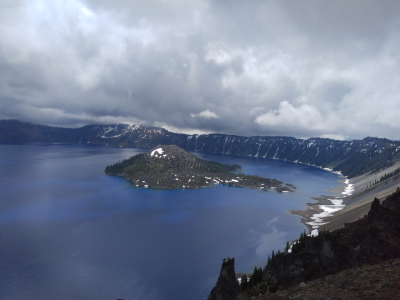
I was attending the Rotary International Conference in Portland and had a free day so I drove south along the Oregon coast and then east over to Crater Lake NP. Crater Lake contains the deepest freshwater lake in the USA at 1,932 feet deep and 7th deepest in the world. Mt. Mazama about 12,000 feet tall erupted and collapsed within 6,800 years ago forming the deep basin or caldera. Snow melt and rain filled the caldera. No streams enter or escape the lake. A natural marvel, rain totally refills evaporation that takes place. The lake is stocked with salmon, rainbow trout and brown trout.
The NP was established in 1922 by President Roosevelt and gets about 45 feet of snow annually. I drove around Rim Road, a 33-mile perimeter road that goes all the way around Crater Lake viewing the unique cinder cone called Wizard Island which stands 750 feet above the water & looks like a wizard’s hat (Photo#1 & #4). Peaks around the rim range from 6,100 to 8,100 feet high. I pulled off the road, hiked a half mile and ate lunch at Whiteback Pine Picnic Area, enjoying the majestic view. Later I took a photo of The Phantom Ship (Photo#2), a unique rock formation in the water. Later at the Rim Visitor Center, I purchased several books about Sasquatch reports of which many sightings were from nearby places in Oregon and northern California. Rosie and I returned in 2022 and hiked four trails and on one trail, I re-proposed to her, which was a pledge that I made back when I hiked here in 1990.
Expedition Team: Dave Miller, Rosie Miller, Matt Miller, Jacque Miller, Holly Miller, Shane Miller
Date: July 8, 2005
Our first National Park stop on our 13 state 5,500 mile trip. We camped at the local KOA campground where we videotaped a tarantula which crawled over my shoe while filming. The kids also chased lizards, jack rabbits and found a giant black beetle. The NP has over 100 known caves including Lechuguilla Cave, the deepest limestone cave in the USA at 1,567 ft. We sat on bleachers at sunset and I videotaped 500,000 bats (Photo #6 & #7) exit the cave right before dusk at feed on moths and beetles as they are important insect exterminators. They would come out as a continuous giant swirling mass, gain altitude to clear the cliffs and then fly off to search for food. I gave Shane $5 to adopt a bat and he came back in tears as he thought he would get a real bat to take home. Instead it was an adoption certificate and photo of a bat & our money was to help maintain the cave site. We hiked a one mile trail where we saw some lizards and an iguana.
Leaving the KOA the next day, Shane’s suitcase fell out the pop-up campers door so we had to retrace 15 miles until we found it. Lunch was hot Mexican burritos. Heading north we drove through 12,000 ft. mountains and the brakes got hot. We pulled over to let them cool off before heading down to White Sands. Along the way on a peak we stopped at the real Smokey the Bear statue/site. Later we stopped at the Malpais Lava Flow & did a one mile hike.
Expedition Team: Dave Miller, Rosie Miller, Matt Miller, Jacque Miller, Holly Miller, Shane Miller
Expedition Date: 1987 & July 11-13, 2005
We camped at the south rim National Park Camper Village two nights and enjoyed one of the seven wonders of the world. The Grand Canyon is 280 miles long, one mile deep & 1,902 square miles. The one mile upper rim trail gave us great vistas of the God’s incredible canyon as well as many raven and condor sightings. Along the rim trail we visited the National Park Lodge, the Hermits Rest, fed many squirrels and far below saw the many switchbacks on the Bright Angel Trail, our goal to hike the following day.
That night we had a couple small scorpions join us around the campfire where we cooked pizza bagels, told stories and saw several shooting stars. Shane shouted that he found a shiny rock or jewel. Under the glow of the flashlight it was just an SOS pad. The final morning before we hooked up the pop-up camper to leave, we walked the upper trail by the Grand Canyon Lodge. The smoke from forest fires west of the canyon had blown east into the canyon making it difficult to see the beautiful vistas from the day before.
Expedition Team: Dave Miller, Matt Miller, Holly Miller, Rosie Miller
Date: 1987 & July 12, 2005
Rosie and I hiked this trail 18 years earlier (I have Super 8 film of this) but now it was two of my kids and me. We camped at the South Rim National Park Camper Village two nights and enjoyed one of the seven wonders of the world. The Grand Canyon is 280 miles long, one mile deep & 1,902 square miles. Dave, Matt (age 14) & Holly (age 12) hiked the famous Bright Angel Trail on the South Rim side down to Plateau Point and back. Beginning at 6:00am (Photo#1), the dangerous upper section of the trail had lots of steep, curving switchbacks & two tunnels (Photo#2). If you don’t pay attention you fall a long way to your death. We saw bighorn sheep, ravens & Holly fed tame squirrels (Photo#3 & #4) at the two rest shelters where we could refill our canteens. Once we had to squeeze to the side edge of a switchback to allow the donkey train carrying patrons to squeeze by. The donkeys were expensive but carried patrons to and from Phantom Ranch down at the canyon bottom along the Colorado River. The temperature got hotter as the steep descending trail reached the Indian Garden water shelter at mile 4.5 and leveled off to become flat ground. Just 1.5 miles more to go to Plateau Point Overlook. The overlook was perched on a cliff 1,300 feet above the gorge & the Colorado River below. One misstep and it was a fatal drop. We rested, drank water, ate snacks, took photos and saw hikers coming up the trail from below where they had left Phantom Ranch at 5:30am to climb back to the rim.
It took us 3 hours to hike the 6 miles down from the South Canyon Rim to Plateau Point. The climb back challenging as we ascended 3,100 feet. By 11am, rangers on the rim were closing the trail to new hikers because temperatures were becoming too hot in the canyon. Muscle Matt began carrying the knapsack (Photo#8) the last 1/3 of the way up as I was getting hot and tired. We rested and refilled canteens at both water shelters on the way up. Holly said this was the hottest and most tired she has ever been. As we neared the top after a 3.75 hour climb we could see Rosie, Shane and Jacque at the canyon rim. I had Matt film me acting in an “X-Files” scene on the upper switchback trail and I tripped and almost fell over the side. Later I thought, what a bonehead move to almost get killed after hiking 99% of the way. Finally, at the top we posed for photos (Photo#9) both fatigued and sunburned as temperature was 72 degrees on the rim and 85+ below in the canyon. The entire 12 mile Bright Angel Trail hike took 6.75 hours to complete. We drank lots of water & took naps in the camper. Someday we want to go back and hike down to Phantom Ranch, spend the night and then hike back up the next day.