CANYONLANDS NATIONAL PARK Utah

Expedition Team: Dave Miller, Rosie Miller       Expedition Date:   September 23, 2019

This national park looked like a smaller version of the Grand Canyon. We hiked the four mile Cliff Overlook Rim Trail & saw where the Colorado River and the Green River converge in the canyon.  We rested on a ledge at Grand View Point Overlook (Photo #5), had snacks and absorbed the majestic beauty.  Rock cairns marked our trail and we periodically added rocks to each cairn (Photos #6 & #7).  We saw lots of ground squirrels and what looked like prairie dogs. Another trail took us to Mesa Arch, Candlestick Tower & the Woman Washing Arch (Photos #8-#11), all natural sandstone formations. We searched but had no luck finding the elusive western Jackalope, half rabbit-half antelope. But of course we saw many ravens keeping an eye on us in case we don’t make it out.

ARCHES NATIONAL PARK – Double Arch Trail Moab, Utah

Expedition Team: Dave Miller, Rosie Miller     Expedition Date:   September 21 & 22, 2019

We camped in Moab Slick Rock Campground four nights. First night we sat in the park until midnight at the Park Avenue Trailhead (Photo #2) & looked up at the beautiful galaxy for two hours.  You could see thousands of stars and the Milky Way clearly. There are over 2,000 arches in the park.

The next day we hiked three long trails.   Double Arch Trail was the site of a chase scene from “Indiana Jones and The Last Crusade” movie where we posed at the same location as River Phoenix who portrayed Young Indiana Jones (Photos #3, #4 & #5).   On that trail was the famous Face in the Rock (Photo#6).  The second trail was The Windows Trail, a 1.5 mile trail that took us to the Windows Arches, the South Window & the North Window. as well as Turret Arch (Photos #7, #8 & #9).  Along the trail I photobombed a Chinese woman who was having her photo taken.  Within seconds, six screaming Chinese women and Rosie joined in the international photo shoot (Photo #12).  We didn’t understand each others language but everyone was happy.  Behind the Windows Arches on the trail we discovered Foot Rock (Photo #10).


GREAT SAND DUNES NATIONAL PARK DUNE TRAIL Alamosa, Colorado

Expedition Team: Dave Miller, Rosie Miller      Expedition Date:  September 20, 2019

The National Park dunes are the largest in North America located just west of the Sangre de Criston Mountains in southern Colorado.  This was one of the hardest hikes Rosie & I ever did due to the deep, soft sand & high altitude (8,200 feet). We hiked up to the top of the third highest sand dune which was a 610 foot climb. At that summit, we were blasted by 35 mph winds & blowing sand (photo #8). We couldn’t see to continue up any farther to the tallest dune which was the Star Dune at 755 feet which is the highest sand dune in the USA.  Photo #9 is the view from that summit looking back to where we began at the parking lot with the visitor center beyond it.  The little black specs are other climbers.

On the way down a huge gust of wind blew my hat off into the sand about five feet away.  I dove for it but it blew over the edge of the dune.  As Rosie yelled not to leave her as she slowly got buried in blowing sand, I jumped about 25 feet down the dune and grabbed my blowing hat.  Somehow, I climbed the soft sand back up the 30 foot dune and pulled half buried Rosie out of the sand and we continued down the final 400 feet.  Someday I want to return with my children and climb all the way to the summit.

GREAT SAND DUNES NATIONAL PARK MOSCA CREEK TRAIL Alamosa, Colorado

Expedition Team:  Dave Miller, Rosie Miller             Expedition Date:   September 20, 2019

After ascending & eating a short lunch near the Visitor Center, we hiked 3 miles on the beautiful Mosca Pass Trail. The trail winds beside Mosca Creek through forests, open meadows & rocky hillsides while we kept a wary eye open for bobcats.  The third photo is a view from the trail of the Great Sand Dunes which we hiked first that morning.

After returning from hiking we swam at a local swimming pool warmed by hot springs. That evening at the KOA Campground we sat outside in the chilly air and looked up at the beautiful milky way galaxy and thousands of stars. The last photo shows the inside of our cozy, warm travel trailer.

CONGAREE NATIONAL PARK South Carolina

Expedition Team:  Dave Miller, Rosie Miller                         Expedition Date:  July 28, 2019

Rosie & I visited this unique National Park, 27,000 acres of floodplain steeped in folktales, ghost stories and America’s largest remaining tract of old-growth bottomland hardwood forest. We hiked a 5.5 mile trail (the Boardwalk Trail & Weston Lake Loop) which, in the wet season, becomes swampland. Rangers told us to look for 6 types of woodpeckers but beware of the 5 types of venomous snakes plus feral pigs that roam the backwoods. Everywhere, we saw large spider webs with huge, colorful golden silk orb weaver spiders (Photo#4). Saw the famous, tall loblolly pine trees, countless bald cypress trees and turtles (Photo#5). The small cypress “knees” look like small cities of stalagmites (Photo#3). Folklore has it that fairy’s dwell in these pointed little cities. The park looked more like a jungle swamp than a forest. We highly recommend you visit this off the radar national park.

KENAI FJORDS NATIONAL PARK Alaska

Expedition Team:  Dave Miller, Rosie Miller                                                                                    Expedition Date:  July 1, 2018

We left Anchorage and headed south toward Seward.  G Adventures provided a guide, van & trailer for our 8-day, 850-mile trek.  Our group of 13 people (4 from USA, 3 from Switzerland, 4 from Great Britain, 2 from Russia) drove south on Alaska Highway 1.  The road traveled next to Cook Inlet and Turnagain Arms.  This area has one of North America’s fiercest tide swings, some reaching 40 feet at times.  We entered Chugach National Forest, 6 million acres and the second largest forest in the USA.  Our first stop was at Beluga Point on the Cook Inlet where we looked for whales (Photo#1 & #2). The Alaskan Railroad tracks ran parallel to the inlet and to Alaska Highway 1 for many miles. Our group headed to Kenai Fjords National Park (Photo#4-#7). We hiked 2.5 miles on a forest trail which opened onto a rocky granite path to a glacier called Exit Glacier. Signs going back over 100 years showed where the glacier once was before it began melting & receding back up the mountain.  Forty glaciers flow from this NP ice field, with glowing blue ice. We saw eagles and sea lions.

KLONDIKE EXPRESS 26 GLACIER CRUISE Whittier, Alaska

Expedition Team:  Dave Miller, Rosie Miller                                                                                    Expedition Date:    July 8, 2018

Arriving at Whittier via the Alaska Railroad, Rosie and I boarded the 26 Glacier Boat named the “Klondike Express” to go see…..26 glaciers.  The town of Whittier average 20 feet of snow per year while the nearby mountains averaged 100 feet of snow.  During the 140 mile cruise we had an indoor front seat & table in the bow and enjoyed hot smoked salmon stew.  The five hour cruise took us through Esther Passage of Prince William Sound to Harriman Fjord and College Fjord and back to Whittier.

Along the way we saw orca whales, sea otters and many eagles.  One photo I took, not shown here,  shows an orca jumping out of the water.  The orca or killer whale is actually the largest of a group of marine mammals known as dolphins.  Prince William Sound is the home for 6,000 eagles.

We really did go by 26 glaciers on this cruise.  At Surprise Glacier (Photo#5-#7) the boat pulled up very close and you could hear what sounded like thunder as the glacier ice cracked and calved.  Up close the glacier snow looked sparkling blue in color.  A monk from Nepal was on the boat dressed only in a light sheet.  He had to be cold.  We posed with a Merry Christmas sign with a glacier as the backdrop.

On the return trip from the glaciers before reaching harbor we stopped by a bird rookery across the bay from Whittier. Ten thousand kittiwake birds inhabit the rocky cliffs each summer laying eggs.

ALASKA RAILROAD Anchorage, Alaska

Expedition Team:  Dave Miller, Rosie Miler                                                                                      Expedition Date:  July 8, 2018

I surprised Rosie with a special trip.  We hopped on the Alaska Railroad at Anchorage for a 2.5 hour train ride southeast to Whittier.  Before we left Anchorage and it’s suburbs,  you could also see small airplanes in backyards.  The residents only needed a short grass or gravel runway or road to take off and fly anywhere around the state.  We were told one in 50 Alaskans fly airplanes to get around.  Most planes have interchangeable pontoons.

We passed beautiful landscape as the railroad ran parallel to the coast highway past Beluga Point.  You could see the tide was out creating dangerous mud flats.  One cloud that looked like an old airship or dirigible floated by.  The train passed many glaciers along the route.

Along the railway was the former town of Portage, destroyed in the horrific Good Friday earthquake (9.2 on the Richter scale) in 1964.  Ruins of one house remained from the earthquake’s tsunami.  The area’s elevation dropped 12 feet.  The flooding killed all of the green trees and turned them white, due to the influx of saltwater.

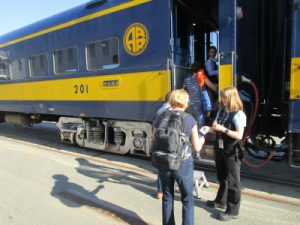
At Maynard Mountain the train went through the 2.5 mile Anton Anderson Memorial railroad tunnel (the longest rail-highway tunnel in the USA) and emerged at Whittier.  Over 90% of Whittier residents (population 400) live in one large apartment tower.  Nearby, several abandoned large buildings used by the Army in World War II as an outpost looked like a haunted  ghost town.  We boarded a large ship the “Klondike Express” for a special voyage out into Prince William Sound to see 26 glaciers.

After embarking from the train, I posed by a totem pole outside of the train station.  Overall, that day we left Anchorage at 9:45am and returned that evening at 9:15pm. It was a great train ride and glacier cruise.

DENALI NATIONAL PARK – WILDLIFE Alaska

Expedition Team:  Dave Miller, Rosie Miller                                                                                    Expedition Date:   July 5, 2018

 There are six major wild animals in Denali – bears, dall sheep, caribou, moose, wolves, red fox.  We saw all but wolves and red fox.  On the return three hour shuttle trip after morning hiking the skies cleared and we saw lots of wildlife and beautiful scenery.  We saw most of the wildlife between Mile 60, the steep, curvy Polychrome Pass at Mile 46 and at Mile 35 on the park road.

We saw many moose but one moose came up very close to use (Photo#1 & #2).  Between 300 and 350 grizzly bears live in the park.  They feed on berries and salmon. We saw several foraging in the distance (Photo #3) plus moose on the run  (Photo#4).


DENALI NATIONAL PARK – DINOSAUR TRACKS Alaska

Expedition Team:  Dave Miller, Rosie Miller                                                                                    Expedition Date:   July 5, 2018

Alaska weather can change fast. What started as a sunny day at mile 1 of the park road turned cloudy, cold with a slight rain 66 miles later at the end of park road.  After I hiked the Gorge Creek Trail we hopped on the park bus for the ride from Mile 66 to the Totlat Visitor Center and restrooms at mile 53.

At the visitor center we had great photos of the Totlat River, valley and distant mountains.  We walked a short trail and saw a replica cast of a cretaceous theropod footprint and a hadrosaur as these real dinosaur footprints were found in 2005 a short distance away from the trail.  The real cast footprint is in Photo#1.  My foot is next to the replica cast (Photo#2) and isn’t even a fifth of the size of the dinosaur.

On benches outside of the visitor center were several moose antlers that we held and tried on.  They were large and very heavy.